You don't have javascript enabled. Please enable javascript to use this website.

My Location — Where Am I?

Instantly compare your IP-based location with precise GPS coordinates.

Network Location

From your IP address · no permission needed

Automatic
City
Not Detected
Region
Not Detected
Country
United States
Internet provider
WINDSTREAM

Usually the city of your internet provider’s nearest hub, not your street.

Precise Location

From your device: GPS, Wi-Fi or mobile network

Your browser asks for permission first. Coordinates are not sent to our server; the map is shown by Google Maps.

Approximate area (IP)

My Location — IP Geolocation and GPS Detection

My Location determines where you are on the internet using two independent methods. IP geolocation maps your public IP address to a city and country using the MaxMind GeoLite2 database — automatically, with no input required. The W3C Geolocation API reads your device's GPS hardware, Wi-Fi positioning, or cellular signals for precise coordinates, but requires your explicit browser consent. Both results are displayed side-by-side with an interactive map that updates when GPS loads.
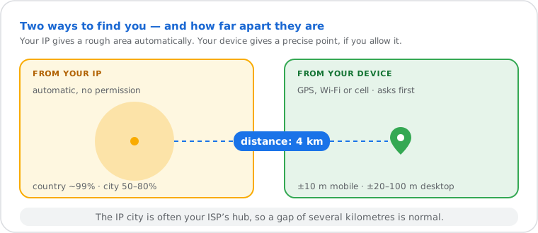
Diagram comparing location from your IP, automatic with country about 99 percent and city 50 to 80 percent, and from your device, with consent and about 10 m precision on mobile, plus the distance between them
The IP city is often your ISP’s hub, so a few kilometres of difference is normal.
Method Data Source Permission Typical Accuracy
IP Geolocation MaxMind GeoLite2 None — automatic ~99% country · 50–80% city
GPS (W3C Geolocation API) Device hardware Browser consent ±10 m mobile · ±20–100 m desktop

How to Use My Location

Instantly detect your approximate IP-based location and compare it with your precise GPS coordinates directly in your browser.

1

Open the Page

Load the page and your IP-based city, region, country, and ISP information automatically appear using your public IP address. No input or permission is required.
2

Review the Network Location Card

Check the Network Location (IP Based) card to view the approximate city, region, country, and internet provider associated with your public IP address.
3

Enable Precise GPS Detection

Click the Pinpoint My Exact Location button and allow browser location access when prompted to retrieve your exact GPS coordinates.
4

Compare IP and GPS Results

Review the updated GPS card showing your exact latitude, longitude, altitude, and accuracy radius. The map switches to your precise satellite location.
5

Understand Location Differences

Compare both cards — the tool shows the distance between your IP location and your device. A large distance means your traffic is routing through a distant ISP hub, mobile carrier gateway, or VPN server.

What Each Location Field Means

Field Source What It Tells You
City MaxMind GeoLite2-City The city associated with your ISP's registered IP block — often the ISP's routing hub, not your physical city.
Region / State MaxMind GeoLite2-City The state or administrative region registered to your IP block. More reliable than city-level data.
Country MaxMind GeoLite2-City The country where your IP block is registered. Accurate in approximately 99% of cases.
ISP (Organization) MaxMind GeoLite2-ASN The Autonomous System Organization that owns the IP block — your ISP, hosting provider, or VPN service.
Latitude / Longitude GPS: device hardware · IP: GeoLite2 GPS coordinates are physical device position. IP coordinates are the centroid of the registered IP block — often a city center.

How IP Geolocation and GPS Detection Work

IP Geolocation — Your public IP address is resolved using the MaxMind GeoLite2-City and GeoLite2-ASN databases, stored locally on the server. When you load this page, your IP is extracted from the Cloudflare X-RESOLVED-CF-IP-ADDRESS header and queried against the database in milliseconds. No third-party API call is made; all processing is local. MaxMind GeoLite2 covers both IPv4 and IPv6 addresses. Database accuracy is approximately 99% at country level and 50–80% at city level, with mobile carrier and satellite connections typically showing lower city-level precision due to centralized IP routing.

GPS Detection — Clicking "Pinpoint My Exact Location" invokes navigator.geolocation.getCurrentPosition(), the JavaScript interface defined by the W3C Geolocation API specification. The browser collects signals from the device's GPS chipset, visible Wi-Fi access points, and cellular towers, then returns a GeolocationCoordinates object with latitude, longitude, altitude (if available), and an accuracy radius in meters. GPS coordinates are never transmitted to the server — all processing happens in your browser tab.

VPN detection — The server checks the X-Forwarded-For header. If it contains multiple comma-separated IP addresses, the connection is flagged as likely routed through a proxy or VPN. This is a heuristic signal only; dedicated privacy tools that suppress this header will not be detected.

Common Uses for My Location

Verifying a VPN is working. A user connects to a VPN server in Germany and loads this page. The IP-based location card shows Frankfurt, Germany — the VPN exit node — while the GPS card shows their actual city after granting browser permission. The two divergent results confirm the VPN is routing traffic correctly and masking their real IP location.

Debugging geolocation in a web application. A developer builds a site that displays localized content based on visitor IP. They use this page to confirm exactly what city and country their MaxMind-based lookup returns for their current IP block, so they can reproduce the same result in their own code without guessing which database entry applies.

Sharing a precise location for coordination. A traveler arrives at an unfamiliar address and needs to share their exact position with someone picking them up. They click "Pinpoint My Exact Location", allow GPS access, and read off the latitude and longitude coordinates — accurate to within 10 meters — to share via any messaging app.

Frequently Asked Questions About Location Detection

Why is my IP location different from my actual location?
IP geolocation maps your public IP address to your Internet Service Provider's routing hub — not to your home or office address. For example, an ISP serving an entire region may route all traffic through a central city, making every customer in that region appear to be located there. For your physical address, use the GPS option and allow browser location access.
How accurate is IP geolocation compared to GPS?
IP geolocation via the MaxMind GeoLite2 database is approximately 99% accurate at country level and 50–80% accurate at city level, depending on how your ISP has registered its IP blocks. GPS via the W3C Geolocation API is accurate to within 10 meters on mobile devices with hardware GPS, and 20–100 meters on desktops using Wi-Fi triangulation.
Does using a VPN change the location shown here?
Yes. When connected to a VPN, your public IP address changes to one assigned by the VPN server. The IP-based location card will then show the VPN server's city and country, not your physical location. The GPS card is unaffected by a VPN — it reads your device's physical sensors directly. This difference is a reliable way to verify your VPN is working correctly.
Do you store or log my location data?
No. Your IP address is resolved to location data in real time using a local MaxMind GeoLite2 database running on the server — no external API call is made for your IP. GPS coordinates are processed entirely in your browser via the W3C Geolocation API and are never transmitted to our servers or stored in any form.
What is the difference between IP geolocation and the W3C Geolocation API?
IP geolocation infers your approximate location from your public IP address using a database of registered IP blocks — it requires no permission and works on every device, but accuracy is limited to city level. The W3C Geolocation API is a browser standard that reads your device's GPS hardware, nearby Wi-Fi access points, and cellular tower signals for meter-level precision — but requires your explicit consent via a browser permission prompt.
Why does my browser ask for permission before showing my GPS coordinates?
The browser permission prompt is required by the W3C Geolocation API specification. Websites cannot access your GPS coordinates without explicit user consent — this is a privacy protection built into every modern browser. If you deny access, the tool falls back to displaying your IP-based location only. You can revoke this permission at any time in your browser settings.

Related Guides

Guide What Is an IP Address? How Public and Private IPs Work
Understand what your public IP address is, how it is assigned by your ISP, and why it maps to a city rather than your home.
Guide What Is a VPN? How Virtual Private Networks Change Your IP Location
Learn how a VPN replaces your public IP with a server IP in another city or country, and how that affects what this tool displays.
Guide How to Hide Your IP Address and Change Your Location Online
Step-by-step methods to mask the location shown in the IP-based card above, including VPN, proxy, and Tor options.

Check more about your connection

Related Tools

IP Geolocation Lookup
Look up the city, country and ISP of any IP address.
What Is My ISP
See your Internet Service Provider and its network number (ASN).
Proxy Checker
Check if your connection goes through a proxy, Tor or a VPN.
WebRTC Leak Test
Check if your browser reveals your real IP through WebRTC, even with a VPN.